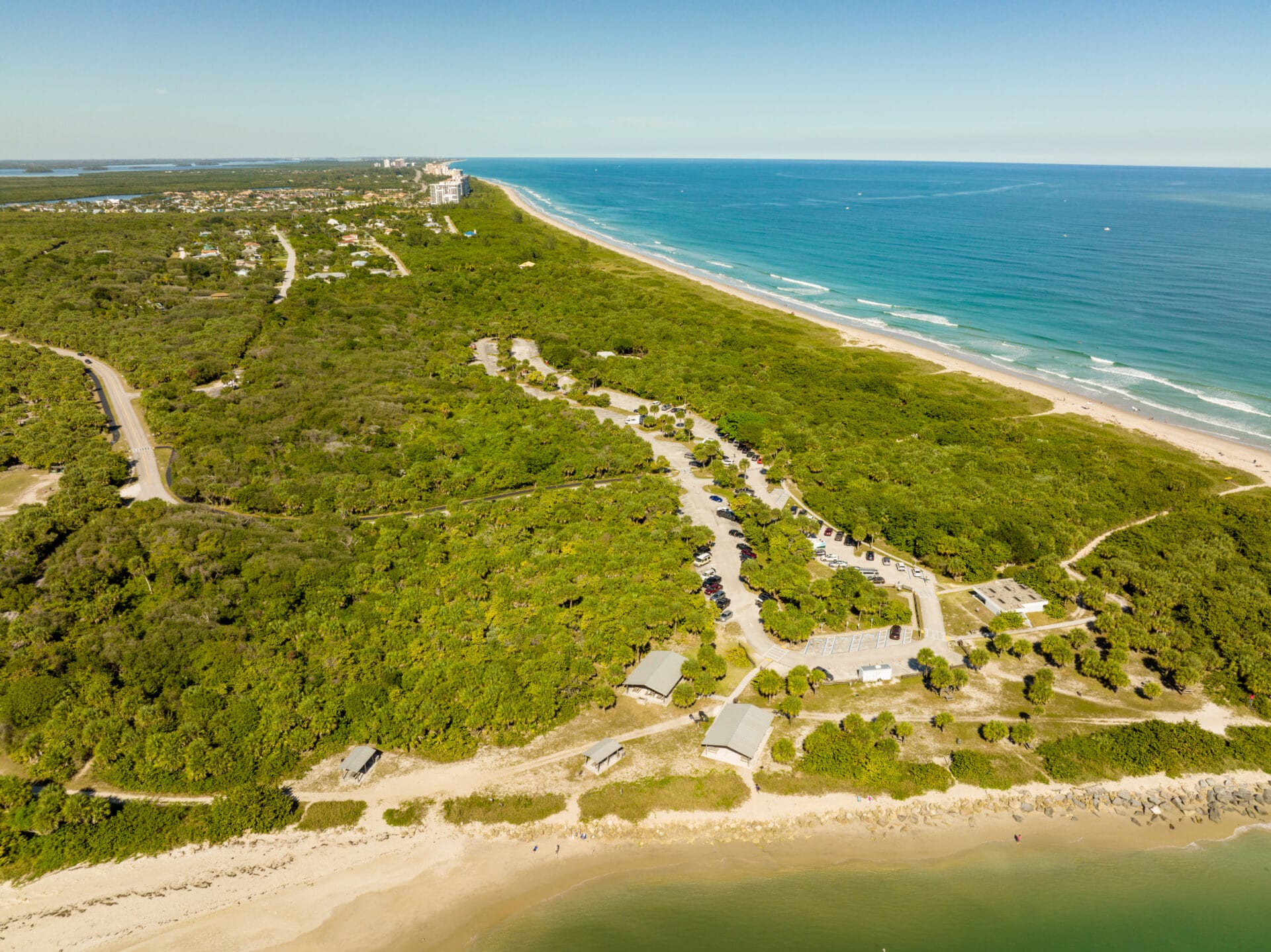

The sands of time….shifting, reforming, just like my childhood memories. 1977–Seventh grade—I remember riding my bike with my best friend, Vicki, out to Hutchinson Island. No traffic. Along the way we would take our hands off the handle bars holding them over our heads, laughing and shouting “look mom!”
A veritable paradise and giant playground we left our bikes at Stuart Beach not locking them and jumped into the ocean.
This photo was taken in 1957, twenty years before Vicki and my bike ride, but it was still relatively undeveloped at that time. If my memory serves me correctly Indian River Plantation’s first condo, The Pelican, went up in 1976 and later in the 1980s the establishment filled out to its final glory. Later sold to the Marriott these lands, though altered, remain a beautiful part of Martin County with public beaches for all to enjoy.
I got ahold of this photo from my mother asking her what kind of vegetation pre-development was on the island. This was her reply:
“This aerial was taken on October 16, 1957. The causeway was under construction as were improvements to Stuart Beach. It is hard to tell what kind of trees are there. They were probably a variety of things, oak, salt bush, cabbage palms, palmetto and Australian pine. The later were growing at the House of Refuge at this time so they were no doubt popping up everywhere. It was “disturbed land” since patches of it had been cleared for farming. Mangrove would be growing along the water but I doubt they had reached inland yet. You can see the new piles of sand indicating mosquito ditches had recently been dug. Notice the little Beach Road.” Historian, Sandra Henderson Thurlow
Thinking a bit more about this area I asked my brother, Todd Thurlow, if this area formed “the fan” because it was once an inlet, such as the Gap, he talks about so much. He sent me this:
“The steady forces of long shore drift have operated over the eons to produce not just the current BI and previous BIs such as the ACR on the mainland, but even the peninsula of Florida itself (Schmidt 1997). The strong linearity of the east central and southeast Florida coastline, its low fractal dimensionality (Rial n.d.), indicates the steadiness and consistent directionality of these forces. Chaotic events like storms, on the other hand, produce drastic BI and lagoonal modifications via overwash and tidal inlet cuts, and leave chaotic, or irregular (“squiggly”) backbarrier shorelines, the former producing overwash fans, and the latter producing flood tidal deltas (Figure 3-6).
Figure 4-19. Cartographic signatures of geomorphic stability and instability. Map to left is most north, right map is most south”
Alan Brech, NEITHER OCEAN NOR CONTINENT: CORRELATING THE ARCHAEOLOGY AND GEOMORPHOLOGY OF THE BARRIER ISLANDS OF EAST CENTRAL FLORIDA, 2004.
——————————
Translation: Breaks occurring during storms create overwash fans. (e.g. IRP and Sailfish Point). Tidal inlets produce flood tidal deltas, somewhat like the old Gilberts Bar. BI = Barrier Island; ACR = Atlantic Coastal Ridge. —-Todd Thurlow, “Time Capsule Flights:”(https://www.youtube.com/playlist?list=PLDaNwdmfhj15bmGNQaGhog9QpkQPAXl06)
The shifting sands of time… So many wonderful memories, and so many more to make as times and sands continue to change.


Jacqui Thurlow-Lippisch
About Jacqui:
Although born at Travis Air Base, California, Jacqui considers herself a native of Stuart, Florida, having moved there at eight months old. Her father’s family, originally from Syracuse, New York, has lived in Stuart since 1952. Her mother is a 5th generation Floridian from Gainesville.
Jacqui is journalism and German graduate of the University of Florida, and an education master’s graduate of the University of West Florida. She went on to teach both English and German and after a serious accident of breaking her neck, started selling real estate. In 2008 she ran for the Town of Sewall’s Point Commission and has served since 2008; She is former mayor. During this time she saw the opportunity to help showcase the work of a locally formed river group, the River Kidz, and this has been her passion ever. She incorporates youth/river education into her political work for the St Lucie River/Indian River Lagoon.
Jacqui is the treasurer/secretary of the Treasure Coast Regional Planning Council; has chaired the Florida League of Cities Environmental and Energy Committee; was chair, and long time member of the Treasure Coast Council of Local Governments; is an alternate for the Water Resources Advisory Commission for the South Florida Water Management District; and a board member for Harbor Branch Oceanographic Institute Foundation. She also serves as an (ex-officio) board member for the Rivers Coalition Defense Fund, and is head administrator for the River Kidz.Jacqui is a Daughter of the American Revolution.
Jacqui’s reach involves not only local, but state and federal government. In 2013, she served on Senator Joe Negron’s panel for the Select Senate Hearing on the Indian River Lagoon and Lake Okeechobee. In 2014, she actively supported the elections of both Senator Joe Negron and Congressman Patrick Murphy who have both been strong supporters of Indian River Lagoon issues. In 2015, she is part of the Florida League Cities Treasure Coast Advocacy team. Jacqui received the Everglades Coalition’s prestigious 2015 “John V. Kabler Award” for “Grassroots Activism.” Most recently she has been recruited as a fellow by the University of Florida/IFAS’s Natural Resources Leadership Institute Class XV.Jacqui is running for Martin County Commissioner District 1, 2016.
_________________________________________
I. SLR/ILR INFO YOU ARE WELCOME TO SHARE:
Click link below to have your own electronic copy of Jacqui’s Aerial Photo Booklet: Lake Okeechobee Releases SLR/IRL 2013: (https://theguardiansofmartincounty.com/wp-content/uploads/2014/04/RiverBookletweb.pdf)
Photos to share: 2013 SLR/IRL releases Lake Okeechobee, C-23; C-24; C-44 and C-25:
Link 1: (https://www.dropbox.com/sh/ycbnj3iw4e63ldg/AADBCrAdYtQ9A8b24phqgHeza?dl=0
Link 2: (https://www.dropbox.com/sh/10yfh08m4dgl78o/AABJ4kgnn2mxu2SYBFLWfQnIa?dl=0)
II. Google Earth/Historic Maps Overlay Flights from my blog, created my brother TODD THURLOW, (https://thurlowpa.com) These flights use Topo and other historic maps combined with today’s Google Earth images –flashing between “yesterday and today–give tremendous insight into water and land changes due to drainage for agriculture and development that have occurred in our region.
1. The Inlets at Peck’s Lake and Jupiter Narrows. (https://www.youtube.com/watch?v=yO650JyADwQ)
2. Hal-pa-ti-okee Swamp: Port St Lucie and Western Martin County. (https://www.youtube.com/watch?v=f2f-e0ul1mY)
3. Bog and Ponds of Martin County, 1940s. (https://www.youtube.com/watch?v=VvH5H0TiG5c)
4. The Spoil Islands of the Indian River Lagoon, Martin County (https://www.youtube.com/watch?v=sODqzQ8EW9o)
5. Capt. Henry Sewall’s Dock, Sewall’s Point, Where Was it Located? (https://www.youtube.com/watch?v=OFkL9YgPSmI)
*6. Where did the South Fork of the St Lucie River and the St Lucie Canal Connect, ca. EDD/ACOE 1915-1923? (https://www.youtube.com/watch?v=gYI34XZUNYs&feature=youtu.be)
7. Sailfish Point’s Erosion, Comes and Goes: 1935-1980 (https://www.youtube.com/watch?v=TW8URTQG2o0&feature=youtu.be)
8. USCG Stations, Ft Pierce and Lake Worth, “Then and Now:” (https://youtu.be/ctEzliyeT8w)
9. St Lucie Shoal and Mt. Elizabeth 1882 (https://youtu.be/x29BSbnXBCI)
10. South Bay and Lake Okeechobee’s Altered Shoreline: (https://www.youtube.com/watch?v=sJkMOIqjr_I&feature=youtu.be)
11. Inlets of Hutchinson Island 1515-1900 (https://www.youtube.com/watch?v=ZhYQz4P1ELM&feature=youtu.be)
12. C-44 Reservoir/STA once Orange Groves: (https://youtu.be/i9h1d1pzfww)